Phase 1 Geotechnical Assessment
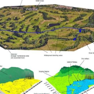
Desk studies and walkover surveys can provide a valuable insight into the likely ground conditions beneath a site at relatively little cost.
Using a combination of historical and geological information, combined with aerial imagery, internet-based research and other data sources, a ground model can be produced to identify geotechnical risks, to guide/ target the next phases of investigations and/ or to provide early indicators of ground-related development costs/ constraints.
Preliminary Sources Study Reports in accordance with HD 22/08 are specifically produced for highways infrastructure projects.